NASA: NOAA-21 Satellite Takes Recent Pictures of Earth
ناسا: القمر الاصطناعي NOAA-21 يلتقط صورا حديثة للأرض
QNA
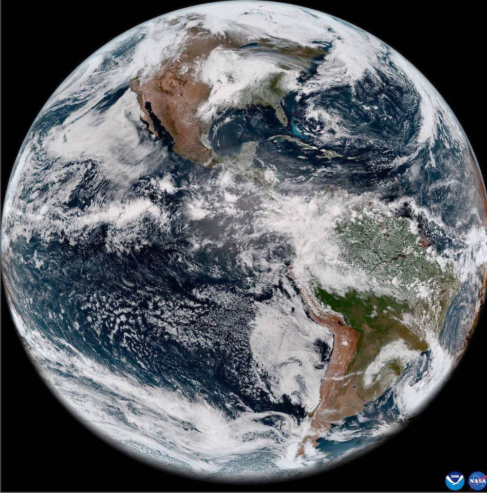
Washington: The US Space Agency (NASA) announced that its satellite, 1NOAA-2, has captured recent pictures of the Earth, as part of its mission.
The satellite will provide a new global perspective of Earth from space and vital information about our planet’s oceans, atmosphere and land. The image is just the beginning of a modern science mission that will monitor the ocean environment and marine health, as well as the ability to track wildfires, droughts and floods.
The satellite contains an instrument known as the Visible Infrared Imaging Radiometer Array (VIIRS), which has begun collecting data, as it measures sea surface temperature, an important measure for monitoring hurricane formation. While monitoring ocean color helps monitor phytoplankton activity – a key indicator of ocean ecology and marine health.
VIIRS on land can also detect and measure wildfires, droughts and floods, and its data can be used to track the thickness and movement of wildfire smoke, collecting images in both the visible and infrared light spectrum. Allowing scientists to see details of the Earth’s surface, it also provides analysis of the world’s snow cover, ice, clouds, haze, aerosols, dust and crop health.
It is worth noting that the NOAA-21 satellite is the second operational satellite in the (GPS) series, and its mission is expected to be about seven years. It was launched into orbit from the (Vandenberg) space base on Nov 10, 2022, while the previous version was launched as ‘NOAA-20’ in Nov 2017, a third operational satellite in the GPS series is scheduled to be launched in 2027, and a fourth in 2032.
قنا
واشنطن: أعلنت وكالة الفضاء الأمريكية /ناسا/ عن التقاط القمر الاصطناعي/1NOAA-2/ التابع لها صورا حديثة للأرض، وذلك في إطار المهمة التي يقوم بها.
وسيوفر القمر الاصطناعي منظورا عالميا جديدا للأرض من الفضاء ومعلومات حيوية حول محيطات كوكبنا، والغلاف الجوي والأرض، حيث إن الصورة هي مجرد بداية لمهمة علمية حديثة ستراقب بيئة المحيطات والصحة البحرية، فضلا عن القدرة على تتبع حرائق الغابات والجفاف والفيضانات.
ويحتوي القمر على أداة تعرف باسم مجموعة مقياس الإشعاع المرئي للتصوير بالأشعة تحت الحمراء (VIIRS)، والتي بدأت في جمع البيانات، حيث يقيس درجة حرارة سطح البحر، وهو مقياس مهم لمراقبة تكوين الإعصار، بينما تساعد مراقبة لون المحيط في مراقبة نشاط العوالق النباتية – وهو مؤشر رئيسي لبيئة المحيطات والصحة البحرية.
كما يمكن لنظام (VIIRS) على اليابسة اكتشاف وقياس حرائق الغابات والجفاف والفيضانات، ويمكن استخدام بياناته لتتبع سمك وحركة دخان حرائق الغابات، وجمع الصور في كل من أطياف الضوء المرئي والأشعة تحت الحمراء، مما يسمح للعلماء برؤية تفاصيل سطح الأرض، ويوفر أيضا تحليلا للغطاء الثلجي والجليد والسحب والضباب والهباء الجوي والغبار وصحة المحاصيل في العالم.
الجدير بالذكر أن القمر /NOAA-21/ ثاني قمر اصطناعي تشغيلي في سلسلة (جي بي اس)، من المتوقع ستكون مهمته حوالي سبع سنوات، وقد انطلق في المدار من قاعدة (فاندنبرغ) الفضائية في 10 نوفمبر 2022، في حين تم إطلاق الإصدار السابق – المعروف باسم /NOAA-20 / في نوفمبر 2017، ومن المقرر إطلاق قمر اصطناعي تشغيلي ثالث في سلسلة (جي بي اس) عام 2027، ورابع في عام 2032.


